Access the data


derived products of STRM30 PLUS v6
Disclaimer: Texas A&M University assumes no responsibility or liabilities for any reliance on the information presented.
Estimated seafloor topography in the Gulf of Mexico is a derived product from SRTM3_PLUS V6.0. Note that the spacial accuracy between land and ocean is different. The elevations in the land are an exact copy of the SRTM30 grid. The resolution is 30 arc second, which is approximately 1 km. However, the ocean data are based on a 1-minute predicted depth grid (approximately 1.85 km or 1 nm resolution).
ArcGIS isobath shapefile
(isobath_5-100m.zip) (10 m interval. include 5m isobath)
(isobath_100-1000m.zip) (100 m interval)
(isobath_500-4000m.zip) (500 m interval)
(isobath_all.zip) (5 - 4000 m. all of the above)
ERDAS IMAGINE image (ready to be used in ArcGIS)
(w98e78n31s18_srtm30.img) (6.7 MB)
(w98e78n31s18_bathy.img) (8.1 MB) (land elev. is 0)
Access the Data: SRTM30PLUS CRM MB-Pts MB-GRID MB-UTM Shapefiles Shoreline Links
Description:
SRTM30_PLUS V6 (http://topex.ucsd.edu/WWW_html/srtm30_plus.html)
SRTM30_PLUS version 6 global bathymetry grid is developed at Scripps Institution of Oceanography University of California San Diego. Data source: SIO, NOAA, U.S. Navy, NG, GEBCO.
img
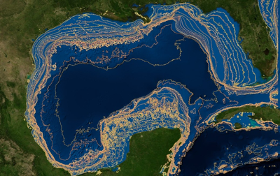
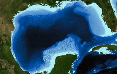
The image file (w98e78n31s18_bathy.img) was created and cropped from SRTM30_PLUS w100n40.Bathymetry.srtm data using ArcGIS. The boundaries of the image are -78 to -98 longitude, 18 to 31 latitude, which include a part of the Caribbean sea as shown above. The datum is same as original file: Clarke 1866.
_srtm30.img is a cropped data of w100n40.bathymetry.srtm in the specific extent described above.
_bathy.img is a modified _srtm30.img by changing all land elevation as 0.
zip (shapefile)
Isobath shapefile was derived from the image above using ArcGIS 3D analyst contour function. The isobath includes 10, 20, 30, 40, 50, 60, 70, 80, 90, 100, 200, 300, 400, 500, 600, 700, 800, 900, 1000, 2000, 3000 m depth. The datum is Clarke 1866.
txt (ascii file)
gom_bathy_srtm30plus_asc.txt was created by converting _bathy.img into ESRI ascii raster file. (about ascii raster format. http://resources.esri.com/help/9.3/arcgisengine/java/GP_ToolRef/spatial_analyst_tools/esri_ascii_raster_format.htm)
gom_srtm30_plus.txt is a downloaded file from the SRTM30_PLUS v6 with the specific extent shown above. This is a tab separated xyz text file. We added a sentence as a header in the first row (long lat z). We assume that all latitude and longitude in ascii file is based on the Clarke 1866 datum as is their grid file.
kmz (Google Earth file)
A kmz file was created using ArcGIS. The file contains 100, 200, 300, 400, 500, 1000, 2000, 3000 m depth contour lines derived from the shapefile.
ESRI ASCII Raster format (.txt)
(gom_bathy_srtm30plus_asc.txt) (15 MB)
Original ASCII XYZ data (.txt)
(gom_srtm30_plus.txt) (112 MB)
Google Earth (kmz)
(w98e78n31s18_isobath_100-3000m.kmz)
(100, 200, 300, 400, 500,1000, 2000, 3000 m)

