Access the data

Coastal Relief Model for the gulf of mexico
Disclaimer: All the data have been carefully prepared. Texas Sea Grant College Program, Texas A&M University, or Geoscience Earth & Marine Services, Inc., (GEMS) assumes no responsibility or liabilities for any reliance on the information presented.


Coastal Relief Model
http://www.ngdc.noaa.gov/mgg/coastal/model.html
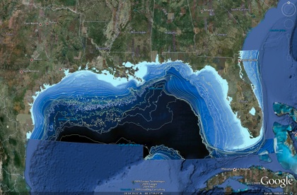
The Gulf of Mexico bathymetry from the NGDC Coastal Relief Model. The domain is the rectangular region 26-31N, 98-81W, and a strip 25N, 80-89W.
The strip 25N, 98-89W does not appear on the NGDC CDROMS as this region is not part of the US EEZ. The first figure shows the domain coverage.
The data was extracted at a resolution of 3 and 15 arc-seconds (around 90 m and 462 m horizontal resolution respectively).
The output files are:
-
1.ASCII data in two data formats:
-
a.long, lat, elevation without header
-
b.ArcGIS Ascii raster format http://resources.esri.com/help/9.3/arcgisengine/java/GP_ToolRef/spatial_analyst_tools/esri_ascii_raster_format.htm
-
2.ERDAS IMAGINE image file derived from xyz data
-
3.Isobath polyline shapefile derived from the image above. 10, 20, 30, 40, 50, 60, 70, 80, 90, 100, 200, 300, 400, 500, 600, 700, 800, 900, 1000, 1500, 2000, 2500, 3000, 3500 m depth contour lines.
-
4.KMZ file. Isobath shapefile were converted to KMZ file which can be opened via Google Earth. 100, 200, 300, 400, 500, 1000, 2000, 3000 m depth.
-
★3 arc second (~ 90m) resolution bathymetry
(ArcGIS Ascii raster) (1.1 GB)
(3 arc-sec ERDAS Imagine img) (467 MB)
-
★15 arc second (~ 500m) resolution Bathymetry
(15arc-sec ERDA Imagine img) (34 MB)
-
★ Isobath shapefile
(crm_gom3arc_isobath.zip) (shapefile, 25 MB)
(crm_gom15arc_isobath.zip) (GMT contour, 1.2 MB)
-
★ Google Earth KMZ file
(crm_gom3arc_isobath.kmz) (KMZ, 7 MB)
Access the Data: SRTM30PLUS CRM MB-Pts MB-GRID MB-UTM Shapefiles Shoreline Links
